 Cascarta is an innovative web-based mapping tool that allows emergency managers, land use planners, and others to visualize the resiliency of the built environment, including critical lifeline utilities and social infrastructure, and the cascading effects of a disaster. The website provides a user-friendly method to increase understanding of a community’s resiliency.
By identifying and assessing the relationships and dependencies between critical utility and social infrastructure assets, users are able to pinpoint areas of vulnerability and proactively mitigate risks and build additional redundancy into community systems.
Cascarta - Creating a Name
The E & E project team met several times to discuss potential names for the tool. Options the team considered included words in different languages for "cascade" or "waterfall" to capture the idea of cascading impacts, variations of words like "aspect or "axiom" that capture the ideas of having a long view or studying consequences, and the name of Greek gods and goddesses, which would match another web-based mapping tool used by the Larimer County OEM, the Argos tool.
Out of several options, E & E and the Larimer County OEM chose "Cascarta" as the final name for the tool. Cascarta combines "cascata" (Italian for 'cascade') and 'carta geografica' (Italian for 'map') to capture the idea of mapping the cascading effects of a disaster. The main element of the logo design at right is the letter "C", comprised of two abstract cascades. Shades of blue are used to suggest depth and stability.
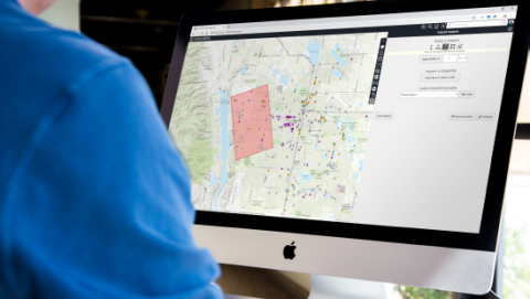 Cascarta allows users to explore relationships between community assets in order to develop an understanding of the resiliency of the built environment and vulnerabilities that may cause cascading impacts within critical lifeline utility systems and social infrastructure, via a user-friendly interface.
- Cascarta provides a powerful tool for emergency managers during disaster response, allowing emergency managers to identify and allocate additional resources to protect high-priority assets based on the potential cascading effects to the community of the failure of these assets.
- As a scenario planning tool, Cascarta supports better communication and collaboration between community planning, public works, and emergency management offices, as well as external stakeholders. The website provides a method to visualize the cascading effects of a multitude of hazard scenarios, allowing communities to identify vulnerabilities and provides data in both visual and tabular formats to support planning and investment decisions.
- Cascarta is available as a free resource to any community. Supplementary materials, including the replication Methodology Memo, User Guide, and Administrator Guide, are available to assist communities in replicating Cascarta on their servers and incorporating this tool in their operations.
Below is a zip file containing all necessary files to begin the process for the creation of your own Cascarta tool. This file also includes the replication Methodology Memo, User Guide, and Administrator Guide. If you have questions please feel free to email Kohl Parrott at parrotck@co.larimer.co.us.
