Page updated 9/5/2025 at 1:00:00 PM MST
🚧 Delays from construction traffic should be expected at all sites.
Carter Lake’s portion of the FLAP project is planned to be completed in 2026.
Carter Lake Map
North Entrance
3798 S County Rd 31, Loveland, CO
🟢 OPEN
South Entrance
6724 W County Rd 8E, Berthoud, CO
🟢 OPEN
Boating
North Pines Boat Ramp
🟡 CONDITIONALLY OPEN
Saturday & Sunday only
- Closed Monday through Friday until further notice.
- Boat ramp and day-use areas remain open on weekends 6 a.m. - 10 p.m. (Saturday–Sunday).
🔴 Paving will be occurring Thursday, September 11 through Wednesday, September 17 - Full Closure
North Boat Ramp (Marina)
🟢 OPEN
- 7 a.m. - 7 p.m. through October 31.
South Shore Boat Ramp
🟢 OPEN
- 7 a.m. - 7 p.m. through September 30.
Day Use Areas
Beginning mid-September, S. County Road 31 will be reduced to one lane between Big Thompson and Quarry Lots.
Big Thompson Day Use Area
🔴 CLOSED
Carter Swim Beach
🟢 OPEN
- Will close for the season mid-September
North Pines Day Use & Parking Lot
🟡 CONDITIONALLY OPEN
Saturday & Sunday only
- Closed Monday through Friday for construction until further notice.
- Boat ramp and day-use areas remain open on weekends (Saturday–Sunday).
Quarry Area Day Use & Parking Lot
🔴 CLOSED
Camping & Pavilion
Make a Reservation
Carter Knolls Campground
🟢 OPEN
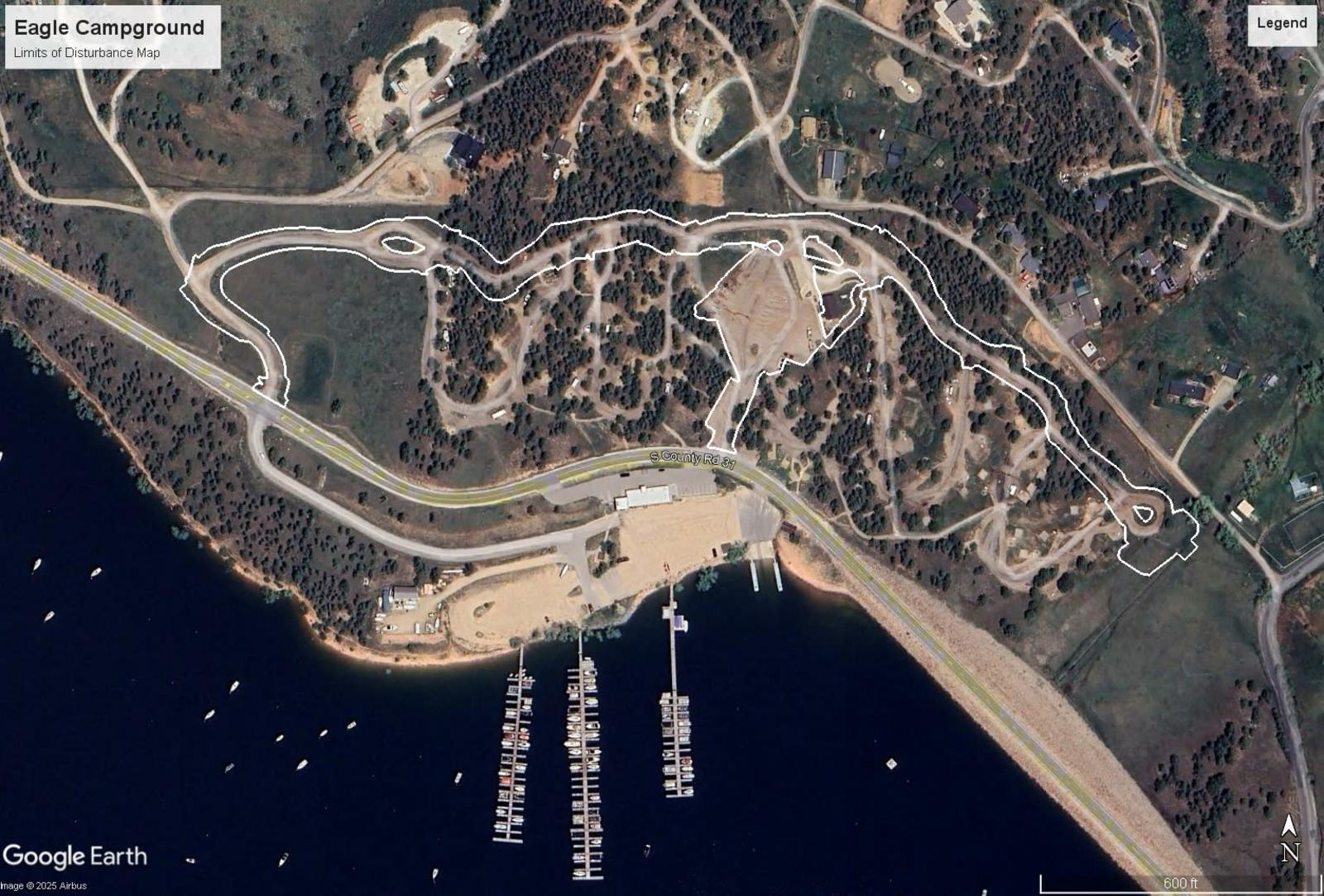
Eagle Campground
🟡 CONDITIONALLY OPEN
Friday & Saturday only
- Sites are reservable on Friday and Saturday nights only, up to 30 days in advance.
- Larger camping units (RV/Trailers over 27 ft) not recommended.
- The Shower House and Overflow Parking Lot have limited access.
North Pines Campground
🔴 CLOSED
Sky View Campground
🟢 OPEN
South Shore Campground
🟢 OPEN
South Shore Group Pavilion
🟢 OPEN
Trails
Fawn Hollow Trailhead
🟢 OPEN
Sundance North Trailhead
🟡 CONDITIONALLY OPEN
Saturday & Sunday only
Sundance South Trailhead
🟢 OPEN
FAQs
-
Can I still park along the county road?
On the east side of Carter Lake, between Dam 2 (the current swim beach) and Dam 3 (near Carter Lake Marina), parking will be affected by construction. Contractors will mark construction areas with signs and cones, so it's important to follow directions and avoid unsafe areas.
Access will be monitored throughout the project, and if safe parking is available without interfering with construction, it will be allowed.
-
Where can I go to picnic or just spend the day?
The paving project will affect areas on the north end of Carter Lake, including Eagle, North Pines, and Big Thompson, as well as shoreline access along S CR 31 between the swim beach and Dam 3. While not all areas will be worked on at the same time, parking and access will change throughout the project. Pedestrian access to the shoreline will generally remain open, but visitors should follow signs and avoid construction zones. The current swim beach parking lot will stay open until the new day-use parking area at Big Thompson is completed, after which it will close.
-
Will camping be available during construction?
Yes, camping will be allowed at Eagle and North Pines campgrounds at certain times. LCDNR is working with contractors to allow weekend camping or limited access as long as it’s safe. Availability will depend on the construction schedule, weather, and other factors. Other camping areas at Carter Lake not directly impacted by the 2025 improvement project include South Shore, Carter Knolls, and Sky View Campgrounds. Make your reservation at larimercamping.com.
-
Will shoreline fishing be allowed?
Fishing from the shore or by boat will still be allowed during the paving project. Some areas, like the northeast and northwest corners of Carter Lake, may have temporary access closures for safety, but most shoreline access will remain open.
-
Where is boating access allowable?
At first, lake access will stay the same. As construction progresses, the swim area will move to the Big Thompson Day Use area, and motorized boats will be restricted from that zone, marked by “NO BOAT” buoys. These buoys may shift, so boaters should stay alert. Updates will be posted at boat ramps.
-
Where can I go swimming?
Swimming is allowed in the designated swim area, currently located at the corner of Dam 2 or in its future location along the northeast shore. The swim area will be marked with a swim line and 'NO BOAT' buoys to prevent motorized boats. The swim beach parking lot will stay open until the day-use parking area is built at Big Thompson, after which it will be closed. Shoreline wading is permitted along the entire reservoir shoreline, provided individuals can stand on the ground and no motorized boats can pass between them and the shoreline.
-
Will fishing from my boat be affected?
Boat fishing will only be restricted near the designated swim beach area, marked by “NO BOAT” buoys. These buoys may shift as the project progresses, so boaters should stay aware. Updates will be posted at boat ramps.
-
How will boat trailer parking be affected?
Two of the three boat ramps at Carter Lake will be impacted at different times. South Shore ramp will stay open but may see increased traffic. North Pines will have limited parking and single-lane access. At the north ramp, overflow parking may be unavailable during construction, requiring boaters to use other areas once the lot is full.
Boaters should check ramp hours and be alert to night closures when launching. If the exit with spike strips is closed, boats may need to stay on the water overnight until the morning inspector reopens the ramp.
Click a photo to enlarge.
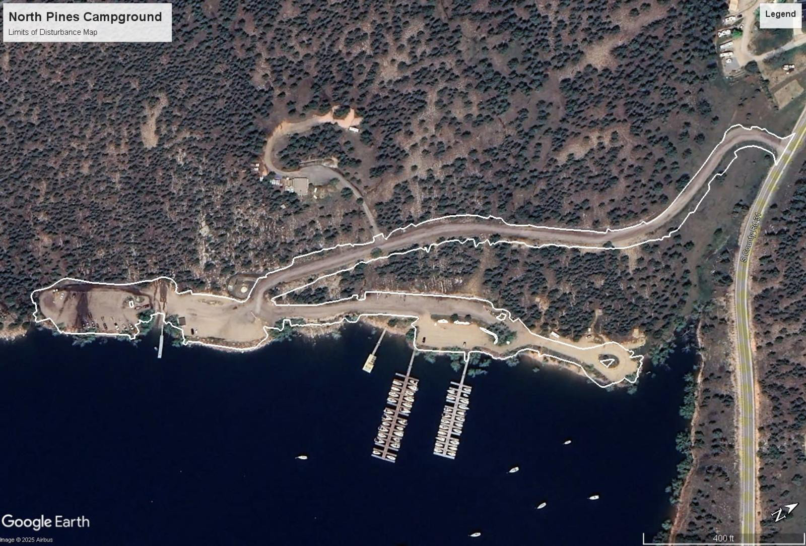
North Pines Campground
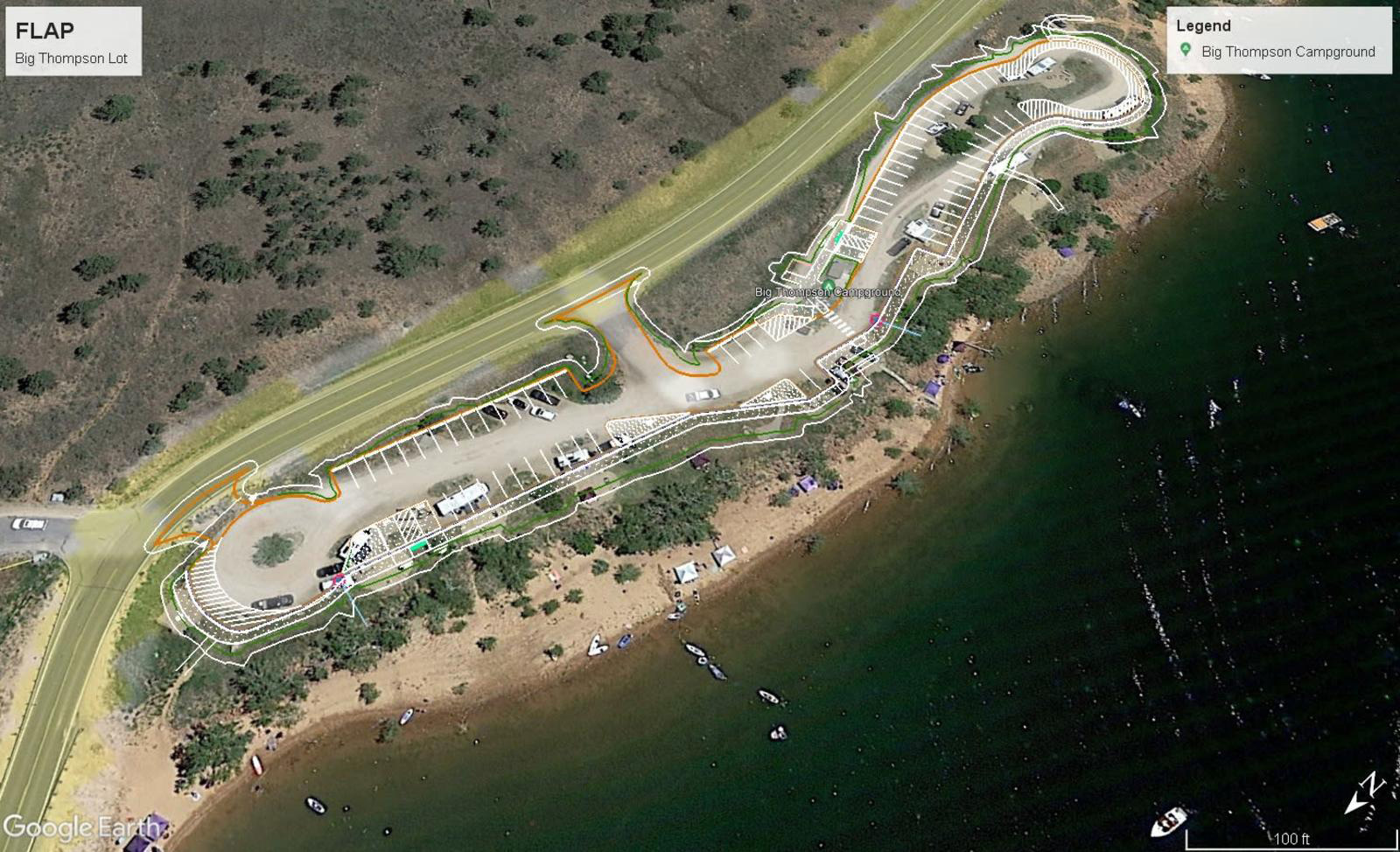
Big Thompson Lot
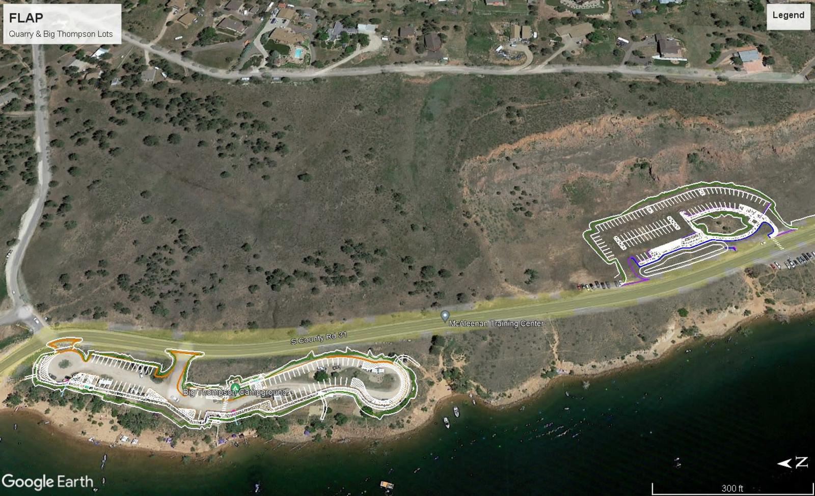
Quarry & Big Thompson Lots
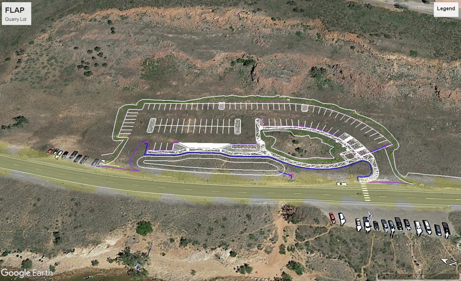
Quarry Lot
Eagle Campground
